- December 10, 2021
- Posted by: noAdmin
- Category: DJI Enterprise Dealer
A quick look at how thermal imaging technology paired with the maneuverability of a drone can benefit your enterprise
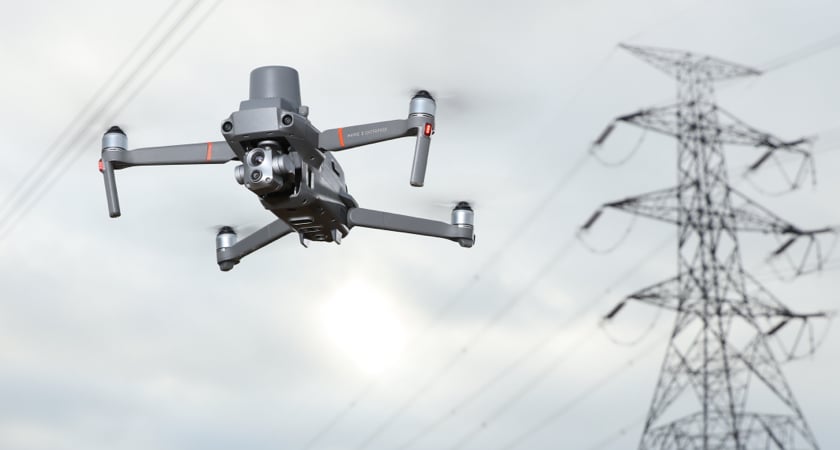
Thermal imaging in small unmanned aerial vehicles (sUAVs) or drones has been gaining popularity in recent years. From land assessment in agricultural settings to power line inspection in the utility industry, and from search-and-rescue scenarios to fire inspection and detection, the applications keep growing.
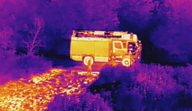
Recently, the thermal imaging capabilities of DJI drones have been instrumental in helping customers around the globe improve safety and performance. In Argentina, DJI drones were used for thermal inspection. In Belarus, DJI drones were used to extinguish wildfires. In the USA, DJI drones were used to assess structural damage prior to firefighters entering an inflamed building. And in Vietnam, DJI drones were used to search for flood and landslide survivors. These are just a smattering of examples demonstrating how thermal drones are helping enterprises operate more efficiently with less risk.
If you’ve been wondering if it’s time to upgrade to a drone with thermal imaging capabilities, this post is designed to help you better understand the underlying technology and to help you better assess the functionality of these devices.
Heat 101
Heat is nothing more than the vibration of atoms: The more they vibrate, the hotter they become. And as atoms vibrate, they create what is known as a heat signature. This heat signature is what is detected by thermal imaging cameras.
Thermography is the field of study dealing with the heat or infrared radiation (IR) that an object naturally emits. Thermographic instruments such as thermal cameras detect and display the heat signatures of both animate and inanimate objects.
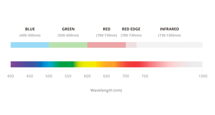
There are a few key factors about thermography that need to be highlighted before getting into the nuts and bolts of thermal imaging. First and foremost, humans can feel heat, but can’t see it because heat occurs on the infrared wavelength of the electromagnetic spectrum. Additionally, the visible light that humans can see is in fact only a small sliver of the electromagnetic spectrum. Thermal cameras, on the other hand, capture infrared energy and render images suitable for our limited vision.
 Secondly, it’s important to note that not all objects emit an accurate heat signature. The degree to which an object absorbs or reflects heat is called emissivity and it varies greatly amongst objects. Furthermore, objects with high emissivity, like wood, can be easily detected by a thermal imaging device while those with low emissivity, like these patio tiles, cannot be easily detected by a thermal camera.
 Wood has high emissivity
How a thermal camera works
Thermal cameras primarily measure the surface temperature of an object and are engineered to detect subtle changes in temperature. However, mirrors, shiny objects, and highly polished areas reflect thermal radiation and thus cannot be accurately measured by a thermal camera. Instead, non-reflective surfaces like concrete, wood, and even humans have a high degree of emissivity, and thus can be more accurately measured using thermal imagery.
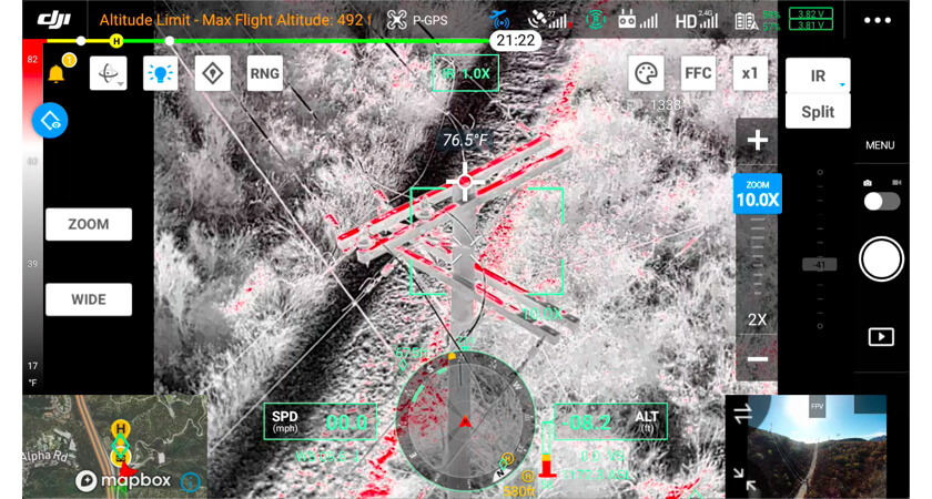
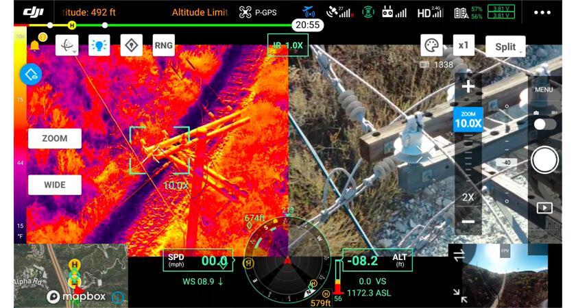
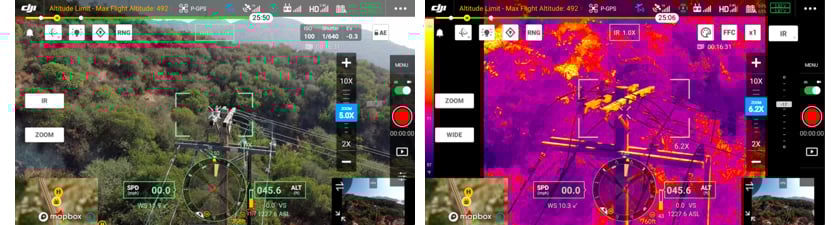 Thermal image of a utility pole captured with the H20T
A thermal camera consists of a specialized lens that allows IR frequencies to pass through. In addition, the camera includes a thermal sensor and an image processor, all of which are housed in a protective case. The camera is typically mounted on a drone’s gimbal which swivels up to 360 degrees and helps to stabilize the camera. As the drone flies about, the camera’s thermal sensor detects infrared wavelengths and converts those into electronic signals. After receiving the signals, the image processor creates what is known as a thermogram or thermographic image which is composed of a color map displaying different temperature values.
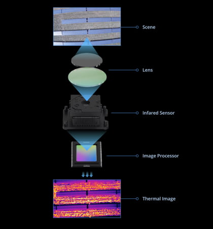
Diagram of how a thermal camera works
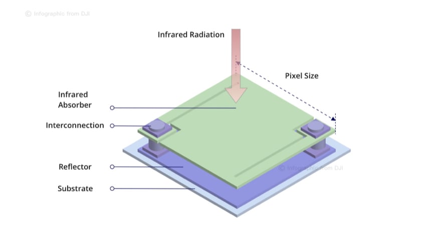 Diagram of a thermal sensor (microbolometer)
In technical terms, the thermal sensor is actually called a microbolometer. This highly sophisticated sensor essentially absorbs infrared energy and then creates a thermogram based on its measurements. Interestingly, past microbolometers had to be contained in exotic cooling materials and were thus considered “cooled”.As a result, those early microbolometers were very expensive. Luckily, technology has advanced to a point where the microbolometers can now be “uncooled” and still provide exceptional quality.
Reading thermal images
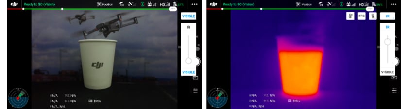
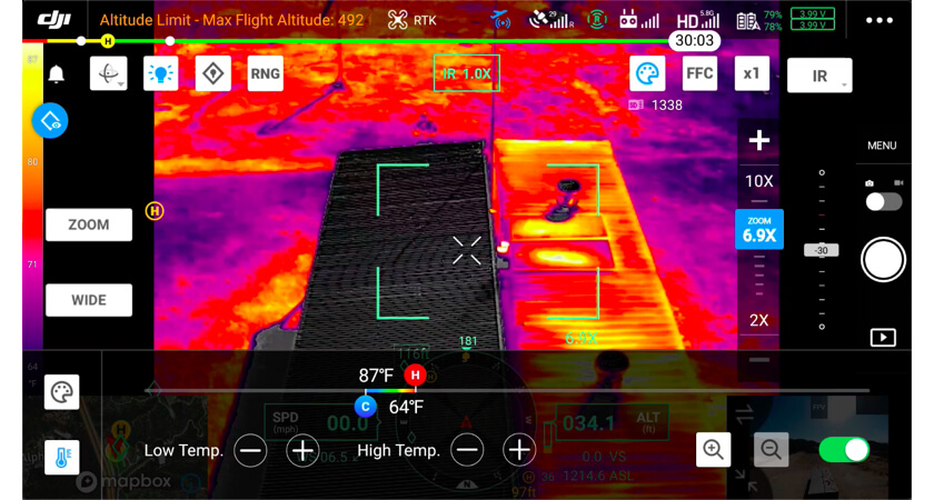
Drone thermal imaging software offers a variety of color palettes to choose from. Those palettes typically range from a hot white setting with hot items displayed in white and cooler items displayed in black, to a hot black configuration where the color patterns are reversed. Another common color palette is the rainbow setting which shows heat in a range of colors with the hottest items displayed in red, orange, or yellow while colder temperatures are displayed in blue or black.
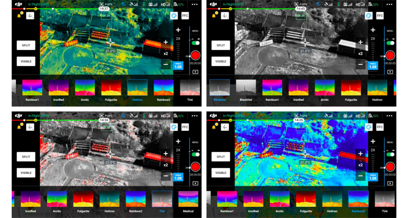 Common thermal color palette settings
More advanced drones usually offer a wider variety of color palettes so that consumers can select the most optimal display for their particular needs. For instance, DJI’s Zenmuse H20T thermal camera provides twelve color palettes that are mapped to 256 colors and displayed in 8-bit JPEG or MPEG-4 formats.
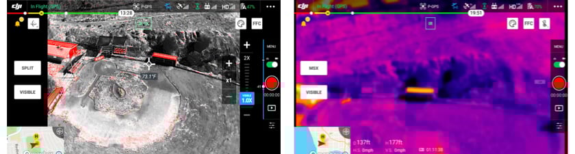
Thermal camera image processing
After capturing thermal camera images, the drone’s software displays each clip in an onscreen gallery much like how a smartphone displays captured video segments. Customers can then use a variety of software packages to inspect and edit those images.
Generally, lower-end thermal cameras simply capture thermal images without the temperature readings. In contrast, higher-end cameras such as the Zenmuse H20T measure thermographic data in each individual pixel and consequently record the actual temperature readings along with the thermal images. This level of detail, along with the geotagged GPS information for each photo, makes image assessment much faster and more convenient.
 DJI in-flight thermal imaging software
Surface readings
Although highly sensitive, thermal cameras can be affected by numerous factors such as the time of day, surface conditions, and an object’s reflectivity. Atmospheric conditions such as warm air, humidity, clouds, rain, and snow can also significantly reduce the accuracy of a thermal reading. Moreover, smoke, dust, and debris can have a negative impact.
The surface coating of an object can also play a factor. For instance, two objects made of the same material can receive varying thermal camera measurements if one of the objects is corroded or newly painted or altered in any way from the other object. In this case, the thermal camera would generate different temperature readings for both objects.
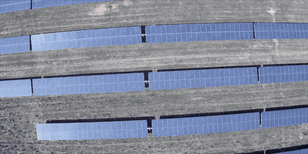
Other factors can also play a role in affecting thermal measurements. For example, in the image below, the solar panels are all made of the same material, but some are generating different thermal readings due the position of the camera in relation to the position of the sun.
For these very reasons, it is important to always make a careful assessment of your thermal readings before coming to any conclusions.
 Surface readings by thermal cameras can be affected by a number of factors
A common fallacy is that thermal cameras can see through glass. In fact, they cannot. Instead they simply measure the surface temperature of the glass without peering through it. Nonetheless, it can be difficult for thermal cameras to obtain an accurate measurement of a glass object as it may be reflecting the heat of the sun, or the ground, or other objects near it.
Surface-reading factors to consider
Some of the factors affecting the accuracy of thermographic temperature measurements are:
- Atmospheric conditions
- Smoke, dust, and debris
- An object’s emissivity
- An object’s transparency
- An object’s reflectivity
- The time of day
- The angle of viewing
- The type of paint on an object
- The camera’s distance to an object
- The amount of thermal energy in an area
- The roughness or smoothness of an object
It also should be noted that a thermal camera cannot detect gas leaks. However, DJI does offer a laser methane gas detector called the U10 which can be seamlessly integrated with the Matrice 300 RTK and the Matrice 210 RTK V2.
To learn more about drones in HazMat response, click here.
Dual camera systems
Dual camera systems shoot both thermal and color images simultaneously. A good illustration of this feature is DJI’s Zenmuse H20T hybrid thermal payload which is two cameras in one: a regular visible light camera and a thermal imaging camera. Commonly, dual camera systems utilize advanced software to provide more accurate thermal readings.
 Split mode with the Zenmuse H20T
Isothermals
An isotherm is a user-defined temperature setting. This feature allows customers to set specific temperature ranges to be displayed on a drone’s control panel in order to highlight hotspots. For example, a forest ranger may be looking for high temperature readings to be alerted to potential fires, and thus could set the thermal drone’s monitor to display only isothermal readings in higher temperature ranges. As a result, the forest ranger would be alerted to potential hazards in real-time while flying a thermal drone instead of waiting for recorded images to be rendered and then analyzed.
 TempAlarm with the Zenmuse H20T
Next generation of aerial thermal imaging
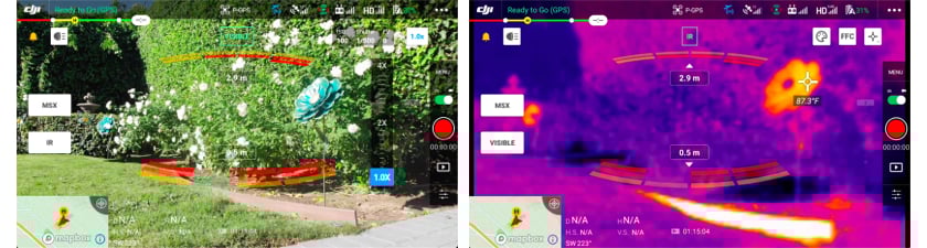
Drones with integrated thermal sensors like the Mavic 2 Enterprise Advanced can measure thermographic information in complex conditions such as fog and smoke. Moreover, the Zenmuse H20T has advanced software capabilities which enable users to set alarms when temperatures exceed certain parameters, track the temperature of highlighted objects, check real-time temperatures with one touch of the screen, superimpose a visible light object over a thermal object, and optimize image clarity.
 The Mavic 2 Enterprise drone with thermal imaging camera and visible light camera
Thermal camera price points
It should be noted that not all thermal cameras are alike. For this reason, there are several key factors to keep in mind when deciding to purchase one, such as:
- Field of View (FOV) refers to the size of the observable image that the camera picks up.
- Weather resistance denotes how well an electrical enclosure can stand up to the elements and is measured in Ingress Protection (IP) levels. If you anticipate your missions will expose your drone and thermal sensors to adverse weather like rain or fog, it is recommended you consider the M300 RTK + H20T combo which boasts industry-leading weather resistance.
- Spectral band refers to the electromagnetic range that the camera’s sensor can detect.
- Thermal sensitivity denotes how sensitive the thermal camera is and to what degree the camera perceives differences in temperature. This is also referred to as noise equivalent differential temperature (NEDT).
- Image resolution refers to the size and number of pixels an image contains as well as how detailed the image is.
 Mavic 2 Enterprise Advanced: 640×512 sensor (left) vs. Mavic 2 Enterprise Dual: 160×120 sensor (right)
Use cases
As the technology in this exciting field grows, drone enthusiasts are finding more and more ways of using thermal imaging devices. For example, sUAV thermal cameras are now being used to improve the efficiency of solar plants, to track and inspect livestock, to rapidly detect overheating switches on electrical distribution lines, to inspect equipment at mines, to manage agricultural systems, and to improve security. These are just a few of the unique use cases for thermal drones and as the technology improves, the list of applications will continue to expand.
To help you decide if a thermal imaging device is right for your unique set of circumstances, contact a DJI representative in your area.