Our platform allows you to explore open and confined spaces by immersing yourself in the environment. The customization of the platform, the GIS integration and the possibility of collecting many data allow favor the use of the platform in the Oil & Gas, Solar, Real Estate, Heritage sectors.
Click below to try it!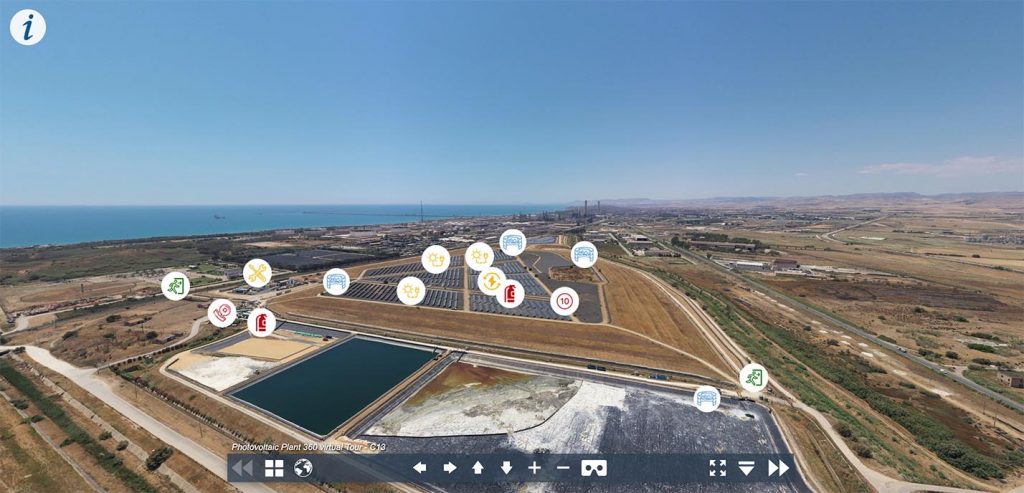
Challenge
In complex enviroments such as Photovoltaics or Oil Plants, getting a comprehensive view from the ground can prove to be quite challenging.
Having a global point of view can greatly facilitate most crucial decision, relating in particular to:
- Safety planning:
Which are the main exits of the plant? Where should the workers involved gather if any security concern is raised? Is there any possible obstruction present?
- Mainteinance Optimization:
What are the parts that are most exposed to the natural elements, or that are more subject to wear?
- Risk assestment:
Is there any possible risk for the health of the workers or to the integrity of the assets?
- Future developments:
What would be the most beneficial way to carry on with an expansion project?
Solution
Thanks to a customized reconstruction workflow, it is possible to rapidly capture and genererate ultra-high resolution 360 images that, taken from particular point of interest, are able to offer a complete point of view and interconnect in order to making remote exploration possible.
- Planning:
Not every enviroment is equal, and an adequate planning is crucial in order to satisfy even the most ambitious client. During the first phases, we work in close contact with the end-user to better understand which parts of the asset inspected needs to be covered in greater detail, in order to aquire an adequate number of hotspots.
- Flying:
Flights are carried on by experienced pilots, and can be executed with low-weight drones in order to comply with every safety regulation.
- Reconstruction:
Using a customized reconstruction workflow, we are able to deliver 360 images that are both ultra-high resolution (>300Mpx) and georeferenced, so that they can be easily connected to eachother and be shown on a map.
- Delivery:
The main deliverable, beside the raw images, is a web-application that can integrate additional data such as PDF reports, close-ups, videos etc., which can both be hosted on our platform or directly on the clients hardware, if required.