Plant Intelligence for Targeted Action
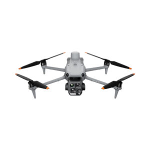
Gather precise plant-level data using the P4 Multispectral – a high-precision drone with a seamlessly integrated multispectral imaging system built for agriculture missions, environmental monitoring, and more.
Farm to Figures
Gain Immediate Insights into Plant Health
The P4 Multispectral consolidates the process of capturing data that gives insight into crop health and vegetation management. DJI has created this platform with the same powerful performance standards that DJI is known for, including 27 minutes max flight time and up to 7 km1 transmission range with the OcuSync system.

See Beneath the Surface
Agriculture imagery collection is now simpler and more efficient than ever before with a built-in stabilized imaging system that collects comprehensive data sets right out of the box. Access information collected by 1 RGB camera and a multispectral camera array with 5 cameras covering Blue, Green, Red, Red Edge, and Near Infrared bands – all at 2 MP with global shutter, on a 3-axis stabilized gimbal.
Integrated Spectral Sunlight Sensor for Accurate Results
An integrated spectral sunlight sensor on top of the drone captures solar irradiance, which maximizes accuracy and consistency of data collection through different times of day. When combined with post-processed data, this information helps to obtain the most accurate NDVI results.
Meaningful Data at Your Disposal
View Both RGB and NDVI Feeds
Simply having aerial imagery is not enough for ag professionals who want to know more. Switch between a preliminary Normalized Difference Vegetation Index (NDVI) analysis and the live RGB feed to immediately visualize where attention is needed, so targeted treatment decisions can be made quickly.

Centimeter-level Precision
Get real-time, accurate positioning data on images captured by all six cameras with DJI’s TimeSync system, providing centimeter-level accurate measurements. The TimeSync system continually aligns the flight controller, RGB and NB cameras, and RTK module, fixing the positioning data to the center of the CMOS and ensuring each photo uses the most accurate metadata. All cameras go through a rigorous calibration process where radial and tangential lens distortions are measured. The distortion parameters gathered are saved into each image’s metadata, letting post-processing software adjust uniquely for every user.
D-RTK 2 Mobile Station and NTRIP Compatibility
Enhance the accuracy of RTK positioning without internet connection by connecting the P4 Multispectral to the D-RTK 2 High Precision GNSS Mobile Station and NTRIP (Network Transport of RTCM via Internet Protocol)2, or store the satellite observation data to be used for Post Processed Kinematics (PPK).
Plan Flights
Plan flights, execute automated missions, and manage flight data using GS PRO – DJI’s leading flight planning iOS app.
Capture Data
Collect multispectral images efficiently across a large area using the P4 Multispectral and gain an overview of problem areas.
Analyze Data
Easily access and process aerial data by applying plant-specific metrics and parameters to acquire the desired results on plant health.
Act on Data
Implement targeted treatments on areas that need attention based on accurate drone data.
Applications

Precision agriculture
Throughout all growing seasons, multispectral imagery can be helpful to ag professionals by providing information invisible to the human eye across the electromagnetic spectrum. Having access to this data and the subsequently obtained Vegetation Index data such as NDRE and NDVI, farmers can make timely, informed decisions on crop treatment, lowering costs, saving resources, and maximizing yields.
Environmental monitoring and inspection
Routine inspections and maintenance involving plants can be made smarter and more efficient when using the P4 Multispectral – leverage its actionable multispectral insights to monitor forest health, measure biomass, map shorelines, or manage riparian vegetation while protecting habitats or ecosystems, and much more.
How is the P4 Multispectral different from the Phantom 4 RTK?
Both are RTK-enabled, all-in-one drone platforms, and the main difference is the camera. The P4 Multispectral comes with an RGB camera and five cameras that make up a multispectral camera array, all at 2 MP; whereas the Phantom 4 RTK comes with a single RGB camera at 20 MP.
What propellers does the P4 Multispectral use?
It uses the 9455S Low-Noise Propellers. The Phantom 4 Series propellers are also compatible, but flight performance will be affected.
How do I take care the Spectral Sunlight Sensor on top of the drone?
Keep it away from hard, sharp objects to prevent scratching.
What are the capabilities of the multispectral camera array of the P4 Multispectral?
The multispectral imaging system of the P4 Multispectral detects light emissivity of different objects, which is captured by each of the cameras and analyzed to calculate vegetation index values. A common index used in the agriculture and forestry industry for plant health is NDVI. Meanwhile, the spectral sunlight sensor atop the drone compensates for the sunlight received throughout different times of day, improving the consistency of the data captured over the same field of vegetation.
What are the Multispectral Imaging Bands covered by the multispectral cameras of the P4 Multispectral?
Blue (B): 450 nm ± 16 nm, green (G): 560 nm ± 16 nm, red (R): 650 nm ± 16 nm, red edge (RE): 730 nm ± 16 nm, near-infrared (NIR): 840 nm ± 26 nm.
Each Sensor: Effective pixels 2.08 MP (2.12 MP in total)What is the focal length for each camera on the P4 Multispectral?
All the camera lenses have a focal length of 5.74 mm, and the 35 mm equivalent focal length is 40 mm.
How are the cameras radiometrically calibrated? The images will have gone through radiometric calibration when you process them through the vegetation index features in DJI GS Pro and DJI Terra.Have the cameras on the P4 Multispectral gone through image position compensation?
Yes. The positions of the centers of the six cameras’ CMOS relative to the phase center of the onboard D-RTK antenna have been calibrated and are recorded in the EXIF data of each image.
Have the cameras lenses gone through distortion correction?
The original images are not corrected for distortion, but each camera lens has gone through distortion measurement during the production process, with the parameters recorded within each of the images.
Have the cameras gone through vignetting correction?
The original images are not corrected for vignetting, but the parameters for vignetting correction are recorded within each of the images.
Is the TimeSync feature available for all six cameras? Yes.
Do I need to use a high-speed SD card for the cameras? Yes. Please refer to the user manual when choosing an SD card.
How is the consistency ensured across the multispectral camera arrays and the Spectral Sunlight Sensors on different drones?
All P4M aircraft go through a standard camera and sensor calibration process as part of DJI’s production standards, minimizing differences between drones.
What are stored in pixel values of the images, DN values or reflectance values? DN values.
Which remote controller is compatible with the P4 Multispectral?
Currently, the P4 Multispectral is only compatible with the SDK Remote Controller that comes with the aircraft.
Can I use other Phantom 4 Series remote controllers to control the P4 Multispectral?
You will be able to link the aircraft and a Phantom 4 Series remote controller, but you will not be able to control the P4 Multispectral if you’re not using a compatible remote controller. You can use the P4 Multispectral remote controller with the Phantom 4 RTK, but not the other way around.
What is the max transmission distance of the P4 Multispectral?
NCC / FCC: 7 km; SRRC / CE / MIC / KCC: 5 km (Unobstructed, free of interference)
What is the resolution of the transmission of the P4 Multispectral? 720p.
Can I use the P4 Multispectral battery on the Phantom 4 RTK? Yes.
How long does a P4 Multispectral battery last? A new battery lasts around 27 minutes.
How long does it take to charge a P4 Multispectral battery? Around 58 minutes.
How do I run firmware upgrades on the P4 Multispectral?
You can run firmware upgrades using DJI Assistant 2 for Phantom. Follow instructions https://www.dji.com/downloads/software’s/assistant-dji-2-for-phantom here and in the user manual.
What apps are available on the remote controller for field scouting and inspection?
The operating app that comes with the aircraft, DJI GS Pro, can be used to plan flights and execute flight missions.
What map is used in the app for the P4 Multispectral? DJI GS Pro uses Apple Maps.
Is there a limit on the number of waypoints for each flight?
There is no limit on the number of waypoints in each flight mission, but the aircraft can only perform actions at up to 99 waypoi
nts. When a flight mission has more than 99 waypoints, DJI GS Pro will automatically section the waypoints into groups, each containing a maximum of 99 waypoints.
What are the limits to flight height and speed?
Flight height: Maximum: 500 m, minimum: 1 m.
Flight speed: Maximum: 15 m/s, minimum: 1 m/s.Which flight mode should I use if I want to switch between RGB and NDVI live feeds?
You can switch between RGB and NDVI live feeds in manual mode. We recommend that you stay in the RGB view and do not switch between feeds during a flight mission. The JPEG images will automatically be saved in either RGB or NDVI based on the camera mode. Most third-party mapping software will require RGB images for aerial triangulation before stitching NDVI maps.
What are the recommended camera settings?
For beginner users, we recommend setting the multispectral shooting mode to Auto, choose Average Metering as the metering mode, and choose AE unlock.
Does the P4M support third-party software?
Support for DJI Mobile SDK is coming soon.
Which vegetation indices are support in DJI Terra?
NDVI, GNDVI, NDRE, LCI, OSAVI. But it does not have a vegetation index calculator function.
Which types of crops can information from the P4 Multispectral be used for?
The data from the multispectral bands captured by the P4 Multispectral can be used for a variety of crops or vegetation. Use DJI Terra or third-party software to reconstruct vegetation index maps like NDVI or NDRE maps that help you monitor plant health.
Can I run routine inspections on a given flight path using the P4 Multispectral?
Yes, you can plan flight missions and execute them repeatedly using GS Pro.
Can I reconstruct maps using third party software? Yes.
How do I calculate an appropriate flight altitude based on a Ground Sample Distance (GSD) value?
The GSD for the P4 Multispectral is (H/18.9) cm/pixel. You can calculate the height of your flight mission based on the accuracy needed.
What’s the max mapping area in a single flight?
It has a max mapping area of approx. 0.47 km2 for a single flight at an altitude of 180 m, i.e., GSD is approximately 9.52 cm/pixel.
Do mission waypoints contain any altitude information?
Relative altitude (relative to your takeoff point) information is stored in the photos captured at waypoints.
Is the P4 Multispectral compatible third-party base stations?
No, you cannot connect third-party base stations to the P4 Multispectral or the remote controller via a radio station. However, you can obtain data from a network RTK server via NTRIP protocol in 4G/Wi-Fi network environment. Satellite observation data can also be saved in the aircraft for users to conduct post processed kinematics (PPK) to complete their tasks.